Update 3 September 11, 2009
Crestwood Public Drinking Water Supply Contamination
Crestwood, Illinois
Cook County
Groundwater Modeling & Bedrock Well Installation
Sampling results from the Illinois Environmental Protection Agency’s (Illinois EPA’s) June 2009 field work near Playfield Cleaners indicate that an area of shallow groundwater at the Playfield Plaza is contaminated with drycleaner solvent and its breakdown products, all volatile organic compounds (VOCs), originating from contaminated soils at the Playfield Cleaners site. Shallow groundwater sampling results from the field work near Playfield Cleaners and the former Crestwood Public Water Supply (PWS) Well #1 did not allow the Illinois EPA to conclusively identify Playfield Cleaners as the source of the Crestwood PWS Well #1 VOC contamination. However, we suspect that dissolved contamination from this site migrated downward into the groundwater of the bedrock and eventually contaminated the Crestwood PWS Well #1.
In consultation with the Illinois State Water Survey, Illinois EPA hydrogeologists have conducted groundwater modeling to simulate the effects of pumping the former Crestwood PWS Well #1 on the deeper, fractured bedrock groundwater and also on the shallow groundwater found in the overlying sand and gravel in the area. While the Crestwood PWS well was operating, this modeling predicts that pumping of the bedrock groundwater would have allowed contamination from the Playfield Cleaners site to move into the well. In order to assess these modeling results, the Agency will drill one new monitoring well into the fractured bedrock.
Groundwater Concepts
To explain our groundwater modeling results, we first need to explain a few basic concepts of hydrogeology.
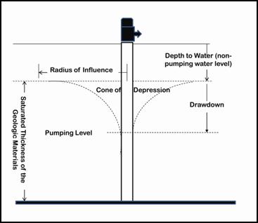 Figure 1. Conceptual cone of depression caused by a pumping well
The withdrawal of groundwater by a well causes a lowering of water levels in the water table around the well. The difference between water levels during non-pumping and pumping conditions is called drawdown( Figure 1). From a three-dimensional perspective, the pattern of drawdown around a single pumping well resembles a cone, with the greatest drawdown adjacent to the pumping well. The water table drawdown area affected by the pumping well, therefore, is called the cone of depression.
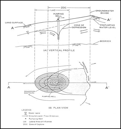 Figure 2. Conceptual cone of depression, lateral area of influence (LAI) and zone of capture (ZOC)
The cone of depression’s rim delineates the outside edge of the well’s lateral area of influence (LAI). The three-dimensional region of groundwater entering the well’s LAI boundary is referred to as the zone of capture (ZOC) (Figure 2). The ZOC is the entire three-dimensional region from which groundwater is eventually pulled into a pumping well.
When the Crestwood well was pumping, in addition to the horizontal and vertical movement of groundwater through soil and bedrock toward the well, gravity caused shallow groundwater to also flow downward from the overlying sand and gravel into the well’s cone of depression. This downward vertical gradient of groundwater flow carried dissolved contaminants downward in the form of a plume of contamination; chemicals dissolve in groundwater to differing degrees (VOCs dissolve poorly in water).
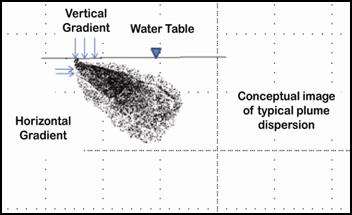 Figure 3. Cross-section of contaminant plume dispersing in groundwater
A contaminant plume in groundwater is like a plume of smoke from a smokestack moving and dispersing in the direction the wind is blowing, downwind from the smokestack. Instead of wind, groundwater flow acts to disperse and move dissolved contamination through soils and fractured bedrock (Figure 3) in the direction groundwater is flowing, downgradient of its source.
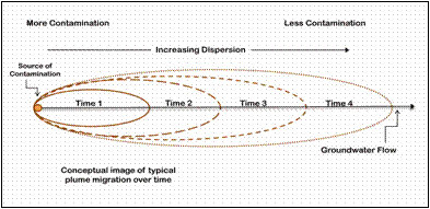 Figure 4. Surface view of contaminant plume migration over time
A contaminant plume, moving down-gradient from a source of contamination, will dilute and disperse over time (Figure 4). Unlike the effect of wind on smoke, the effect of groundwater flow on the movement of a contaminant plume through soils and bedrock is typically measured in inches or feet per year.
The concentrations of contaminants in a plume typically decrease with increasing distance from the source by mixing with uncontaminated groundwater and according to physical effects and biochemical properties of the dissolved chemicals and the soils and/or bedrock through which they are moving. In the Crestwood situation, the original drycleaner solvent plume would have degraded into other contaminants over time and dependent on the presence of oxygen and bacteria, even as physical dispersal of the plume continued. Because these contaminants are denser than water, although they have differing densities and solubilities, we expect this plume of contaminants to have also moved downward, through the groundwater from the shallow sand and gravel at the source area, into the groundwater of this fractured upper layer of the bedrock. The expected movement of the contaminant plume from Playfield Cleaners would be through the overlying sand and gravel, and downward, through fractures in the bedrock aligned in the direction of groundwater flow.
Groundwater Modeling
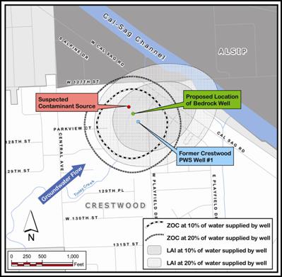 Figure 5. Modeled LAI and ZOC of the former Crestwood PWS well
Modeling predicts that contaminants from Playfield Cleaners solvent release area would have been captured by the former Crestwood PWS well and pumped to the surface (Figures 5 and 6). The groundwater modeling results demonstrate that the Playfield Cleaners solvent release area was within the LAI of the former Crestwood PWS well; this is the only drycleaner facility on record to have been located within the LAI and within the ZOC (Figure 5).
The LAI depicted by the light stippled pattern is the surface area of the extent of the cone of depression modeled when the well was pumping at 20% of well contribution to the PWS system; the inner area depicted by the darker stippled pattern shows the LAI at 10% well contribution. The outer dashed ring represents the extent of the modeled ZOC when the well was pumping at 20% of well contribution to the PWS system; the inner dashed ring shows the extent of the ZOC at 10% well contribution.
The former PWS well is modeled to have captured groundwater out to the edge of the ZOC. The cone of depression created by the pumping of the former PWS well would have formed in the saturated upper layer of sand and gravel down through the upper four feet of the fractured bedrock layer and, as depicted by the LAI, encompassed the drycleaner solvent release area, approximately 290 feet from the well.
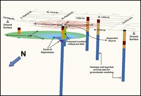 Figure 6. Vertically exaggerated cross section of the modeled water table surface and cone of depression of the Crestwood PWS well
Modeling Verification: Install and Sample a Bedrock Well
In order to assess these modeling results, the Illinois EPA has contracted with an environmental engineering firm to install and sample one small-diameter monitoring well drilled into the fractured bedrock. The well will be drilled 15 feet into the fractured portion of the bedrock, which is the upper 75-100 feet of the bedrock. Our purpose is to try to determine if the drycleaner solvent contamination has moved into the groundwater of this fractured layer as predicted by the modeling.
Based on the modeling, we have selected a well location between the sealed former Crestwood PWS well and the Playfield Cleaners site to try to verify this modeled movement of contaminants into the fractured bedrock. However, groundwater and contaminant movement through fractured bedrock is difficult to predict, so installation of one well into this fractured area of the bedrock may not yield definitive sample results. Because this well’s location and depth into the fractured bedrock represents our best professional judgment concerning well placement, this well is our best attempt to verify our modeled contaminant movement from the Playfield Cleaners site into the former PWS well; the Illinois EPA will not further investigate the deep bedrock beyond the installation and sampling of this one deep well.
Bedrock Monitoring Well Installation and Sampling
Drilling of the bedrock monitoring well is scheduled to begin the week of September 14, 2009, weather permitting. The location of the well will be directly between the suspected source area, the Playfield Cleaners site, and the abandoned and sealed Crestwood PWS Well #1. The well will be drilled to approximately 47 feet below ground surface. Fifteen feet of the well depth will be drilled into the fractured bedrock.
Once the well is completed and allowed to equilibrate with the bedrock formation, the well will be “purged,” or emptied several times, to ensure the water taken for sampling is unaffected by the drilling process. The well will then be sampled immediately to obtain groundwater representative of the fractured bedrock formation. The groundwater collected from this well will be analyzed for the entire family of VOCs to which the drycleaner breakdown products belong.
Why don’t you uncap the Crestwood PWS Well #1 and sample from it rather than drill an expensive new well?
The Crestwood Well #1 was sealed when it was abandoned. This means that the piping of the well shaft was pulled out and/or a powdered clay (bentonite), cement and/or concrete was poured down the well shaft to prevent the well from ever being used again. Sealing of the well effectively renders it unusable.
Also, even if we could sample from the former well, we would gain no further insight into the source of the contamination from sampling at the original well site. In order to link the former Crestwood PWS Well #1 with the suspected contamination source, the Playfield Cleaners site, we need to demonstrate that there is contamination in the fractured bedrock groundwater resource between the two locations.
Is this new well supposed to recreate the construction, depth and pumping influence on groundwater of the original PWS Well #1?
No; this monitoring well will not recreate features of the PWS well. The monitoring well will have a much smaller diameter, will be much shallower, and will be located between the site of the original PWS well and the suspected source of its contamination, Playfield Cleaners. It will be drilled into the fractured bedrock to intercept groundwater at a depth that would have been within the cone of depression created by the original PWS well when it was pumping (Figure 6). A sample of groundwater will be drawn to determine if contamination originating from the nearby drycleaner site is present. If these contaminants are found, this sampling will provide evidence supporting our modeling of the Playfield Cleaners site as the contaminant source.
Will contaminant concentrations found in this new well tell us anything about the contaminant concentrations in the well water while the original PWS well was secretly and illegally operated?
No; any drycleaner breakdown contaminants that are found in sample results from this proposed well will tell us only that our modeling of the past movement of contaminants into the former well reflected actual field conditions.
The operating PWS well’s influences on shallow and deep groundwater over 2½ years ago are very different from the natural forces acting on the groundwater today. While the PWS well was pumping, contaminated groundwater drawn into the area from the Playfield Cleaners site would be expected to mix with uncontaminated groundwater being pulled into the well from the rest of the well’s ZOC. In addition to the dispersion of this contaminant plume over time as it moves in the direction of groundwater flow and downward due to the densities of the contaminants (Figures 3 and 4), this mixing would be expected to further dilute contaminant concentrations found in the former PWS. In fact, the sampling data that have already been shared with the community via our May 8, 2009 fact sheet support the dilution effect predicted by this modeling.
Currently, the natural groundwater flow pattern of the area to the north/northeast is no longer influenced by the pumping of the PWS well and the expected movement of contaminants would be through the overlying sand and gravel and through fractures in the bedrock aligned in the direction of groundwater flow, and according to its physical and biochemical properties. The original drycleaner solvent degrades into other contaminants over time and dependent on the presence of oxygen and bacteria. Because all of these contaminants are more dense than groundwater, though they have differing densities, they would eventually sink through the groundwater column. These contaminants also dissolve in groundwater to differing degrees. The June 2009 Playfield Cleaners soil and shallow groundwater investigation report support this predicted dilution effect.
All of these factors and others — e.g., differences in dilution, change in groundwater flow direction and rate, potentially differential movement of groundwater and residual contamination through two different formations (sand/gravel and fractured bedrock), and the unique physical and biochemical properties of the original solvent, breakdown products and groundwater-bearing formations — introduce complexities that prevent us from accurately modeling, much less physically replicating, actual past concentrations of contaminants in the groundwater at the former PWS well site. Actual contaminant concentrations in the groundwater during the well’s operation have been documented by sampling data collected during the well’s operation and have been shared with the community via our May 8, 2009 fact sheet.
What does it mean if you don’t find contamination in this bedrock well? Will you continue to look for the source of the former PWS well contamination?
Because the Playfield Cleaners site is the only drycleaner site within the former PWS well’s modeled zone of groundwater capture and lateral area of influence, the Agency is focusing its investigative efforts on this site as the most likely source of contamination of the former PWS well. If we find no measurable contaminants in this new bedrock well, it may mean that the bedrock’s natural groundwater flow path to the northeast, not influenced by the pumping of the PWS well for over 2½ years, has moved the plume of dissolved contaminants northward leaving no measurable residual at the location and depth of our new well. Although groundwater and contaminant movement through fractured bedrock is difficult to predict, this well location and depth represents our best professional judgment concerning well placement and is our best attempt to verify our modeled contaminant movement from the Playfield Cleaners site into the former PWS well.
Contact
For more information, please contact the Illinois EPA Office of Community Relations. Additional documents not available on this webpage may be obtained through a Freedom of Information Act request or through IEPA Document Explorer.