Performing Well Surveys
- 1. Background
- 2. Why does the Illinois EPA require water well surveys?
- 3. Do the research techniques apply to cleanup sites under review by different Illinois EPA cleanup programs?
- 4. What sources should be researched for location of potable wells?
- 5. What information is available on the Illinois EPA's web-based GIS system?
- 6. How do I obtain access to the web-based GIS files?
- 7. How should the water well survey results be reported?
- 8. Are there other survey methods that might be used to identify wells?
- 9. When might a physical well survey be conducted?
- 10. For more information:
- 11. Technical questions about GIS web site:
Requirements exist in Illinois and federal regulations 1 to identify potable water wells in relation to facilities or sites to ensure that these wells are accurately identified and located so impacts and potential impacts from soil or groundwater contamination can be identified. The techniques described in this fact sheet will apply to certain Illinois EPA Bureau of Water sites and to Bureau of Land remedial programs and Resource Conservation and Recovery (RCRA) Permits. Remedial or permit applicants or potentially responsible parties (PRPs) should research individual program requirements to ensure compliance.
Much of the information for indentifying wells can now be accessed through Illinois EPA's web-based Geographic Information System (GIS) database in the Source Water Assessment Program (SWAP). An additional requirement is to contact the public water supply to indentify properties that receive water from the public supply. Implementation of these techniques will provide the level of detail necessary to make informed decisions to protect well users.
When a site is being investigated for contamination, it is necessary to know whether site-related contaminants have affected the groundwater (or may affect it in the future) and, further, whether those contaminants threaten any public or private drinking water supply before decisions can be made about cleanup activities or other site actions.
The basic techniques discussed here are required to perform a well survey. However, the search distances for specific potable wells from a given site may vary depending on program-specific rules, so be sure to consult the program rules. If groundwater contamination has exceeded the Tier 1 remediation objectives of 35 Ill. Adm. Code 742 or applicable Groundwater Quality Standards at 35 Ill. Adm. Code 620 as measured or modeled off-site, the survey area of water supply wells is expanded based on the actual or modeled groundwater plume.
To identify community water supply wells and other potable wells (private, semi-private and non-community water supply wells) within applicable distances as defined by the appropriate program regulations, the following sources should be contacted:
- Illinois EPA, Division of Public Water Supplies;
- Illinois State Geological Survey (ISGS);
- Illinois State Water Survey;
- The local water supply entity to determine what areas/ properties are served by the community water supply.
Please note: The first four contacts listed above may be sufficient for well surveys submitted to the Leaking Underground Storage Tank Program (Leaking UST) by making use of the SWAP - GIS database system.
1 Standards and Requirements for Potable Water Supply Well Surveys (35 Ill. Adm. Code 1600.210); Leaking Underground Storage Tank regulations (35 Ill. Adm. Codes 732 and 734);Site Remediation Program (35 Ill. Adm. Code 740.425(b)(2)(D)); RCRA Permit regulations (35 Ill. Adm. Code 703.183(s)(9); 35 Ill. Adm. Code 703.184(a)(3)); and the National Contingency Plan (40 CFR 300.430(d)).
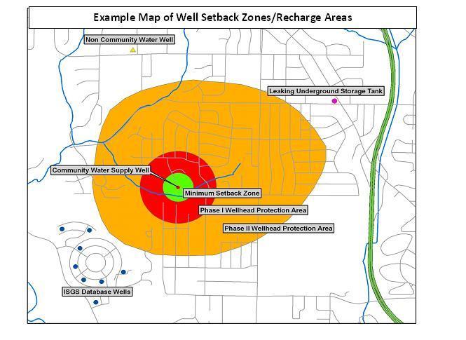
This system shows locations of all community and non-community water supply wells. In addition, the system includes the ISGS database of private and semi-private drinking water wells that have been provided to the Illinois Surveys. The GIS system is the most complete electronic database available. It also shows setback zones and regulated recharge areas for community water supply wells.

Users must complete a confidentiality agreement. Please contact the Bureau of Water Freedom of Information Act officer by email or by calling 217/782-8482. The GIS web page may also be used to find well locations.
The following should be submitted:
- Maps at an appropriate scale showing:
-
- Locations of community and other potable water wells;
- Extent of the measured and modeled contamination plume; and
- Locations and extent of any regulated recharge areas and wellhead protection areas (setback zones),
- Tables showing the setback zone and recharge area for each potable water well;.
- Narrative identifying field observations, persons contacted, and sources of information used; and
- Certification by an Illinois-licensed Professional Engineer or (if regulations allow) by a Professional Geologist .
Yes. Door-to-door interviews with residents, mailing or placing door-hangers asking for a response about potable well locations, and windshield surveys are additional means of obtaining information about potable wells at given locations. These may become necessary when measured or modeled groundwater contamination threatens off-site private wells.
The Agency may determine that a physical survey is necessary when there is reason to believe that potable wells (that were not identified as part of the above data search) exist near a site and may be threatened by contamination from a site. Circumstances that could trigger a more in-depth, physical survey include:
- The local water supply entity does not provide water to a residence/business, but the data search does not reveal a well;
- Wells are identified in a given area but not all residences/ businesses are accounted for and their water source is unclear;
- or
- Other site-specific situations.
Joe Konczyk. GIS Specialist, Department of Innovation & Technology.
Well Survey Rules in Right-to-Know Rules at Title 35, Subtitle O, Ch.1, Part (1600.200):
Revised December 2009

